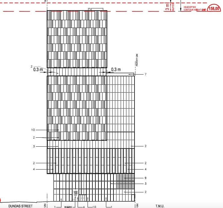
Revised plans for 100 Bond Street in Downtown Toronto reduce the height to 23 storeys from its initial proposal of 30 storeys in June, 2021 (an interim proposal of 29 storeys was made in March, 2023). This change is driven by the need to protect a flight path for the helicopters using the helipad atop St Michael’s Hospital.
The site, less than a 300m walk from Dundas station on Yonge Line 1, spans 54 through 74 Dundas Street East and 98-100 Bond Street.
It currently houses four low-rise commercial buildings, including the Imperial Pub, retail outlets, restaurants, and offices.
The revised Zoning By-law Amendment and Site Plan Control application notes that the reduction in height specifically addresses the revised helicopter path contour height, which has been changed from 178m to 158m above sea level. The revised proposal details a mixed-use building with a 6-storey podium standing 67.45m. This allows for a 3.0m buffer within the revised helicopter contour height limit, in contrast to the previous 30-storey tower proposal with a height of 84.22m.
The federal government, through Transport Canada, has jurisdiction over aeronautics. Recognizing the importance of these helipads, Transport Canada delegated the power to the City to regulate the use of lands in the vicinity of hospital helipads. This move, approved by City Council in July 2016, ensures that developments do not impede the crucial services these helipads provide.
The flight paths for St Michael’s Hospital extend north, west, and east from the facility. This proposal is also under the east flight path for the Hospital for Sick Children (Sick Kids), but it is further away and therefore the protected area is higher here that the St Michael’s north flight path is.
The development’s evolution began with an initial proposal of approximately 287 residential units. After receiving feedback and making subsequent revisions, the number of units increased first to 311, then to 370, before now settling on the current proposal of 336 units. This proposal has a total residential gross floor area of 18,525m², which is nearly 3,000m² less than the previous plan.
The revised proposal, led by developer Bazis and designed by architect Rosario “Roy” Varacalli, includes three elevators, averaging 112 units per elevator. The design also incorporates approximately 666m² of indoor and 336m² of outdoor amenity area, and provisions for 240m² of retail area at-grade, enhancing the pedestrian experience.
Similar to the previous proposal, the design omits residential and visitor parking, but allocates two spots specifically for car-share parking. The two underground garage levels would house 303 long-term and 68 short-term bicycle spaces, in contrast to the 310 and 35 spaces from the previous plan.
100 Bond Street shares the block with Toronto Metropolitan University, which is experiencing a housing crunch for its students. While not being built as a dedicated student dormitory, 100 Bond has a higher than average number studio units which are likely to be bought by investors looking to rent units to students.
UrbanToronto will continue to follow progress on this development, but in the meantime, you can learn more about it from our Database file, linked below. If you’d like, you can join in on the conversation in the associated Project Forum thread or leave a comment in the space provided on this page.
* * *
UrbanToronto has a research service, UrbanToronto Pro, that provides comprehensive data on construction projects in the Greater Toronto Area—from proposal through to completion. We also offer Instant Reports, downloadable snapshots based on location, and a daily subscription newsletter, New Development Insider, that tracks projects from initial application.


