
A Finnish experimentation project developed a framework for classifying ground conditions for building and infrastructure construction. It will help anticipate the future cost of foundation laying during the early stages of city planning.
The ground
conditions of an area can have a substantial effect on the costs and the
environmental impacts of constructing buildings and infrastructure. At early
stage, urban designers don’t typically have enough data to make smart decisions
about zoning in that respect as obtaining that data is time-consuming and hence
also costly.
Consequently, an experimentation project called MAKU-digi: Making the costs of land use visible devised a method for automating the analysis of ground conditions. I had the pleasure of interviewing Juha Liukas, Lead Advisor at Sitowise, and Hilkka Kallio, Geologist at Geological Survey of Finland (GTK), about the project.
Brewing the Idea
“While we
were developing the Citycad software back in the 1990s, we had this idea of
combing a ground conditions map with a town plan for analyzing constructability,”
says Liukas. “One of our clients was the city of Espoo, which had just mapped
out the city’s ground conditions.”
However, turning
this idea into a method and a practical tool did not materialize until much
later. In early 2017, Sitowise, Geological Survey of Finland, and six other
organizations started an experiment as part of the national KIRA-digi
digitalization program. The project was called MAKU-digi.
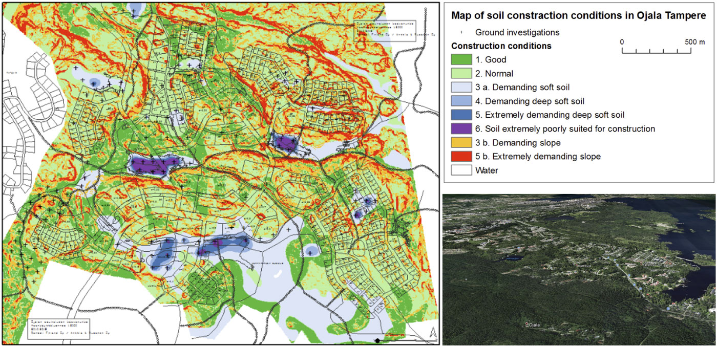
Espoo had
meticulously kept its ground conditions data up to date and was invited to take
part in the project. Other large cities—Helsinki, Vantaa, and Tampere— soon followed
suite, together with the Finnish Transport Agency. They provided the project with
five pilot case studies.
The Sources of Ground
Conditions Data
As ground
conditions data is not readily available in every part of the country, cities use
local geotechnical investigations to augment data from national sources.
“At GTK, we
carried out a 35-year mapping project of superficial deposits, which created
geographic data as polygons,” says Kallio. “This gives an overview of soil
across the country, 1-meter deep. I think, in the beginning, soil mapping was
mainly meant to serve agriculture and forest planning. Today our soil maps are
widely used by land use planners”
Ground-penetrating
radars, satellite imagery, and drone surveys offer additional data that
geological experts can use to estimate ground conditions. However, Kallio
emphasizes that geophysics does not offer alone accurate enough information for
construction purposes. She would rather rely on geotechnical investigations as
primary data.
Automating Geotechnical
Analysis
A two-by-two
kilometer area can involve up to 10,000 individual geotechnical investigations.
Analyzing that amount of data manually is impractical. Thus during the project,
GTK devised and tested a system that automatically identifies certain beds and
strata in the ground.
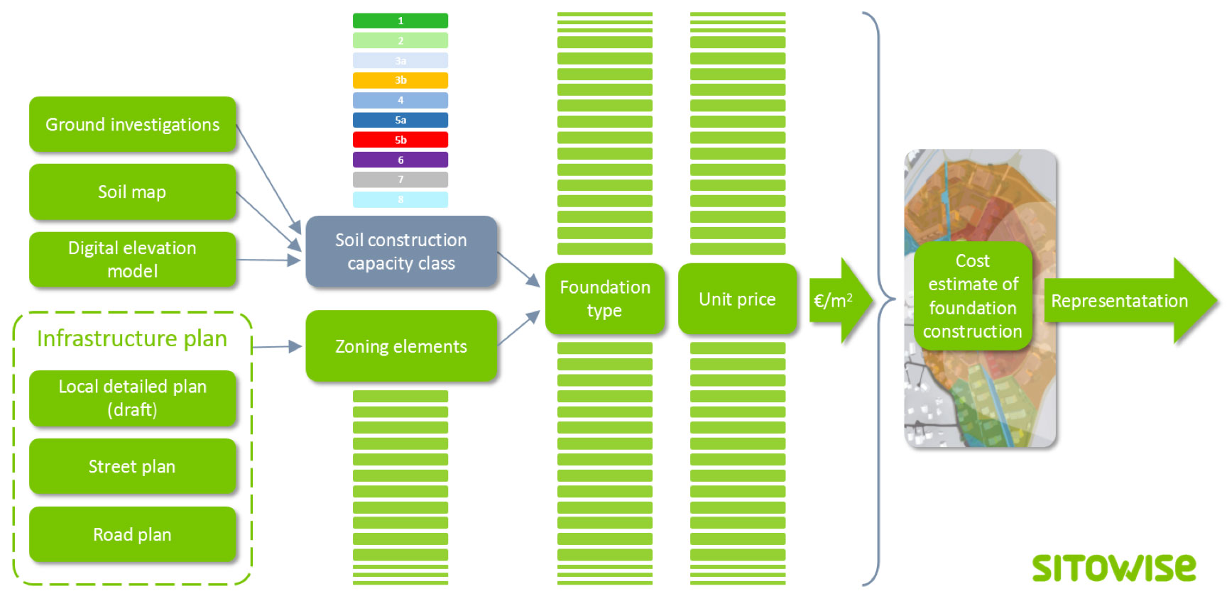
The other
main output of MAKU-digi was a system for using geotechnical investigations,
soil maps, and digital elevation models to classify any geographical location
on a standardized scale. The “soil construction capacity class” of the
location, combined with the location’s zoning elements, determines the
foundation type. It, in turn, has a unit price that when multiplied with the
building area gives an estimate of the foundation costs. The results can be
presented visually on a map.
“In
MAKU-digi, we dealt with the relative rather than absolute costs of foundation
construction. There are other projects, like the national IHKU Alliance, that
will provide a cost management system for infrastructure construction,” Liukas
points out. “I envision a future where you can upload a draft detail plan to an
online service and see the updated foundation costs at once, even as you make
changes to the design.”
Harmonizing Urban Design
Data
“The
Ministry of the Environment saw our results and came to the conclusion that our
harmonized classification model could become a JHS recommendation,” says
Kallio. The so-called JHS recommendations provide national information
management guidelines for both governmental and municipal administrations.
Another
project called Municipality Pilot is formulating a process and information
model for digital detail planning. It has tested combining a detail planning
model with the MAKU-digi analysis in three municipalities.
“I don’t
know of any examples from other countries where a ground condition method and classification
is standardized at the national level. So in that sense, we are doing
pioneering work here in Finland,” Kallio concludes.